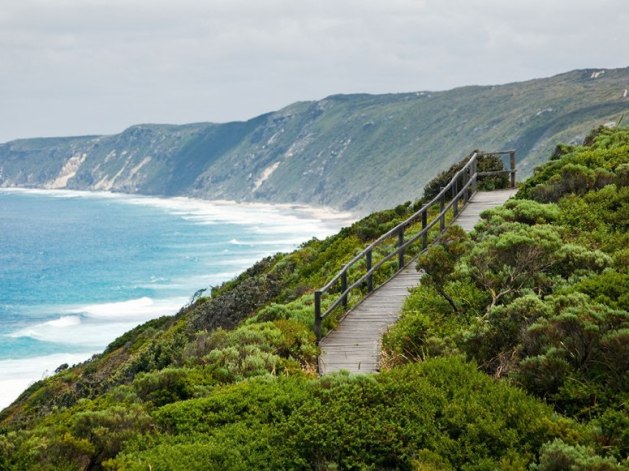
Southwest Australia is one of the worlds 25 biodiversity hotspots and this walk will take you through many of the habitats that make this region so spectacular and world renowned. The entire walk takes six to eight weeks to complete or can be done in shorter stages and is exclusively for walkers only, if you are interested in mountain biking please see the Munda Biddi trail article. The Munda Biddi trail takes a similar course and runs from Kalamunda to Albany as well.
Towns along the trail can be days apart, the longest being 12 days walk so it is important that you carry plenty of food and water. The only source of water on the track is at the campsites which are located a days walk apart, the rain is collected in rainwater tanks which are not filled by any other means. Water may be limited after summer so if you are planning on walking in April/May keep this in mind.
Unlike other famous trails the Bibbulmun is not very crowded and it could be days between seeing other hikers. But it can get busy on long weekends and holidays particularly at the campsites that are easily accessible.
When to go:
Temperatures in the region varies during the year, summer (December – March) is hot and dry with bush fires being a real threat. So the track should be walked in the cooler months (notice cooler- don’t be surprised if in the middle of winter there is at least a few days with temps above 25OC) any time between April and November. October and November can be really hot and dry, and nights get cold in late winter and early spring. Most rain falls in July and August and the southern half of the trail tends to get more rain.
The wildflower season peaks in September and October, can vary based on rainfall and temperatures. The bush comes alive with hundreds of different flowers and colours and should be seen.
Mosquitoes are found throughout the year on the track and the open shelters don’t provide protection from them so a mosquito net is recommended to prevent possible infection with River Ross Virus, some walkers will use the shell (sealed inner) from their tent for protection.
Route:
The track can be walked in both directions, with walkers choosing the direction that suits them or is easier to travel too (more on this later). The most common way to walk is from north to south. The track passes through the towns of Kalamunda, Dwellingup, Collie, Balingup, Pemberton, Northcliffe, Walpole, Denmark and Albany where hikers stay for one or two nights to resupply, wash their clothes and enjoy the hospitality.
The track is well marked with triangular markers with a snake on it, although snakes are commonly found in the bush it is not a warning to walkers, the snake is the Waugal which is a mythological rainbow serpent from the Aboriginal dreamtime. The track is broken down into 9 sections with 8 maps:
Getting There:
If you are walking the entire track you will need to get to/from Kalamunda and Albany. The northern trailhead is on the corner of Mundaring Weir Road and Railway Road, Kalamunda. From the Esplanade busport in Perth you can catch the 282, 296, 299 buses. Check out Transperth for timetables and fees. A taxi from Perth cbd to Kalamunda cost approximately Aud$55, and Aud$36 from the Airport.
The southern trailhead is 409km south of Perth at the Old Railway Station on Proudlove Parade, Albany. Transwa provides buses between Perth and Albany for Aud$59.90 one way. Skywest provides flights to and from Albany for min $186.
Transwa also offers buses from many of the towns along the track to Perth if you want a shorter walk.
Accommodation:
For the majority of the walk you will be camping. There are 49 campsites spaced a day’s walk apart and each has a three-sided timber shelter and are designed to sleep 8-15 people. They are free and offered on a first come first served basis so you should be bring a tent for times when the shelter is full. Each campsite also has a sit-down pedestal pit toilet, rainwater tank, picnic tables and tent sites.
In the towns there are no campsites so you will need to stay in alternative accommodation,
Costs:
Their are no fees to walk the track and stay at the campsites, you will need to pay for accommodation in the towns, food, maps and equipment. There are 8 water resistant rip-proof colour maps that cover the entire track and are essential when taking on the Bibbulmun track as well as 2 compact guidebooks which show car access points, campsites, terrain profiles and distance tables. These are available here, and at some visitor information centres.
Individual maps (1-8) cost Au$11.50 each ($92 total)
or
Northern half map pack (1 to 4) cost Au$42
Southern half map pack (5 to 8) cost Au$42 ($84 total)
Northern Guidebook – covers Kalamunda to Donnelly River Village and includes map 1 to 4 cost Au$35
Southern Guidebook – covers Donnelly River Village to Albany and includes map 5 to 8 cost Au$35
Guided or Solo:
This is a walk that is best done at your own pace and with your own itinerary, if you want to stay a couple of days in a town go ahead or want to skip one you can. But because of the length of time required (not many people have 8 weeks free), or lack of hiking experience there are tours along the track that take in the best sections. The foundation offers tours in May and September that run for 9 days.
Read more on the Bibbulmun Track and more Travel Guides at Knowhow Adventure. You can also find discounted (up to 80% off) outdoor gear for your next adventure.
Article Source: http://EzineArticles.com/?expert=Matt_F_Oldfield


